


What are the GTA 6 map locations?
It has been announced that GTA 6 will take place in Vice City, the playground of the wealthy and a veritable abyss of decadence. Furthermore, there were a ton of details and details about the city and its environs in the GTA 6 teaser.
Even though the release date of Grand Theft Auto 6 is still a long way off, the video contains more than enough teasers to keep us interested until the game launches. We finally have proof of the location of Grand Theft Auto 6’s open-world game, which isn’t a huge surprise after years of speculation. This is all the information we currently know about the GTA 6 map.

Where is GTA 6 set?
The setting of Grand Theft Auto VI is Vice City, in the made-up state of Leonida. Miami and Florida, respectively, serve as the loose inspiration for these locales. It has neon lights, exciting nightclubs, and stunning beaches, just like Miami.
The teaser depicts the congested beaches of Vice City, where enthusiastic joggers and beachgoers in skimpy attire are making sure they’re on track to surpass their personal best. The other areas share the trait of being much more packed than anything else we’ve seen in a Grand Theft Auto game.

Additionally, we saw Vice City’s main strip, which could serve as the focal point of Grand Theft Auto 6. The strip is crowded with lights, music, automobiles, and inebriated pedestrians. Speeding through the streets could get challenging, but as we all know, GTA makes it possible.
Additionally, the trailer features a few non-Vietnam City locales. More precisely, these are rural regions with lengthy highways slicing through the countryside, much like the neighboring states of Florida, especially Georgia. Compared to Vice City’s garish neon-lit streets, these open spaces have a more natural color scheme and appear sparse yet lovely.A brief image displays GTA 6’s recreation of the Everglades, a flooded grassland teeming with wildlife and terrain that is typically only reachable by airboat. Fortunately, one of these is present in the scenario we witness, adding another vehicle to complement the GTA 6 cars we have already seen.
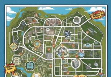
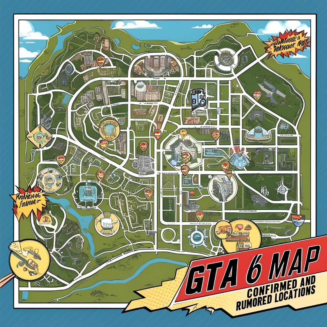
GTA 6 map locations
500 Brickell Condominium
The 500 Brickell, a distinctive luxury apartment complex in Miami’s named Brickell Avenue, is a striking GTA 6 map site from an architectural perspective.
The famous big white roof that connects the West and East Towers is visible from the right-hand side of the shot starting around the 18–20 second mark of the trailer. Grand Theft Auto games have long had lavish home bases, so hopefully the 500 Brickell will be included in the most recent lineup.

Julia Tuttle Causeway
The Julia Tuttle Causeway is a place that is easy to overlook in the Grand Theft Auto 6 video, but it is also depicted on the actual map. Named for the city’s founder, Julia Tuttle, the JTC is the lengthy connecting route between Miami Beach and Miami, Florida, and it is a section of Interstate 195.
A closer look at the screenshot above reveals that there is even a separate mini-island on the right, resembling Biscayne Isle, which is the nearby I-195 in real life. You’ll probably have to utilize the Julia Tuttle Causeway, or whatever GTA 6 calls it in-game, to get from Vice City to Vice Beach, at least until you can acquire fast travel.

Everglades
With the recognizable swampy scenery and airboat, it is immediately apparent that the Everglades are a component of Grand Theft Auto 6. Given the extent of the flooded grasslands—roughly 7800 square miles—we don’t think Rockstar will include the entire vast region in the game.However, the Everglades’ completely different landscapes from those of other GTA city sandboxes will undoubtedly bring some novel gameplay components to exploring and possibly even some of the most recent game’s missions, regardless of how much of it is included.

Florida Keys
In addition to the stunning vistas anticipated in the game’s map, Grand Theft Auto 6’s depiction of the Florida Keys, the state’s well-known archipelago, appears at the 35-second mark in the trailer. Our current examination of the Florida Keys highlights some of the group islands retained in the game, much like its real-life equivalent.
The Seven Mile Bridge, one of the longest in existence at the time of its construction, is another notable feature between some of the connected islands. We don’t yet know how much of the bridge and archipelago will be included in Leonida, but it will make for some smooth driving in any case.

Kaseya Center
In order to avoid missing this one, a GTA 6 recreation of Miami’s enormous Kaseya Center arena in Biscayne Bay appears on the left at the 25-second mark of the clip.
It’s slightly out of focus behind the woman in the convertible, but you can still see the raised platforms on the roof, the flat spherical shape, and the gridded windows. Horizontal slits are also included into the walls of the actual Kaseya Center, but Rockstar appears to have opted for a more zigzag layout to highlight its neon lights.

King of Diamonds
The GTA 6 teaser showed us what is obviously the King of Diamonds strip club on the game’s map just before the 30-second mark. Given its popularity, it makes likely that this, another well-known Miami attraction, would be included in the game.
There are certain clear details in the promo shot that suggest it is Miami’s hangout for well-known rappers, even though typically twerking strippers and purple lighting may just be items on the “insert strip club here” checklist. In addition to the opulent sparkler-featured bottle service that KoD is known for, the stripper platforms are illuminated by fluorescent lights, just like the actual club, and suspended balloons are frequently used as décor.

Miami Beach
It only makes sense that Miami Beach and all of its famous sands would be included in the map of Grand Theft Auto: Vice City. The most striking long image of the game’s captured glistening sands and lush foliage between the city’s tall buildings was of South Beach, which is where we saw the most noteworthy of these shots.

Ocean Drive
One of the most well-known streets in Miami is Ocean Drive, which is also the site of the first safe house in Grand Theft Auto: Vice City and the Ocean View Hotel. The replicated Art Deco hotels, bars, and restaurants that Ocean Drive is famous for, as well as the trees in the center of the South Beach road, are easily seen when comparing the above trailer screenshot to actual photos of the street.

WTVY-TV Tower
The WTVY-TV was immediately noticeable against the front water-covered highway in the first scene of the GTA 6 trailer. Even in its current form, the Bethlehem structure, which stands 579 meters tall as Florida’s highest point, creates a striking effect.
Originally designed as a transmission tower by WTVY station 4, its GTA 6 adaptation is probably going to feature more entertaining video game-style activities, such as attempting to climb to the top and parachute from above. Or simply steal a jet and love it as part of the scenery as you fly by.

Conclusion
This YouTube video is the greatest one we have discovered so far out of multiple attempts to estimate and recreate the GTA 6 map using trailers and other known facts. In order to develop what they believe to be the most realistic version of the GTA 6 map to date, user Dark Space collected theory-crafted material from Reddit and blended it with actual topography.


